Locate a point using the US Army Military Grid Reference System (MGRS)
There is only one rule to remember when reading or reporting grid coordinates, always read to the RIGHT and then UP. The first half of the reported set of coordinate digits represents the left-to-right (easting) grid label, and the second half represents the label as read from the bottom to top (northing). The grid coordinates may represent the location to the nearest 10-, 100-, or 1,000-meter increment.
a. Grid Zone. The number 16 locates a point within zone 16, which is an area 6° wide and extends between 80° S latitude and 84° N latitude (Figure 4-8).
b. Grid Zone Designation. The number and letter combination, 16S, further locates a point within the grid zone designation 16S, which is a quadrangle 6° wide by 8° high. There are 19 of these quads in zone 16. Quad X, which is located between 72° N and 84° N latitude, is 12° high (Figure 4-8).
c. 100,000-Meter Square Identification. The addition of two more letters locates a point within the 100,000-meter grid square. Thus 16SGL (Figure 4-11) locates the point within the 100,000-meter square GL in the grid zone designation 16S. For information on the lettering system of 100,000-meter squares, see TM 5-241-1.
d. 10,000-Meter Square. The breakdown of the US Army military grid reference system continues as each side of the 100,000-meter square is divided into 10 equal parts. This division produces lines that are 10,000 meters apart. Thus the coordinates 16SGL08 would locate a point as shown in Figure 4-20. The 10,000-meter grid lines appear as index (heavier) grid lines on maps at 1:100,000 and larger.
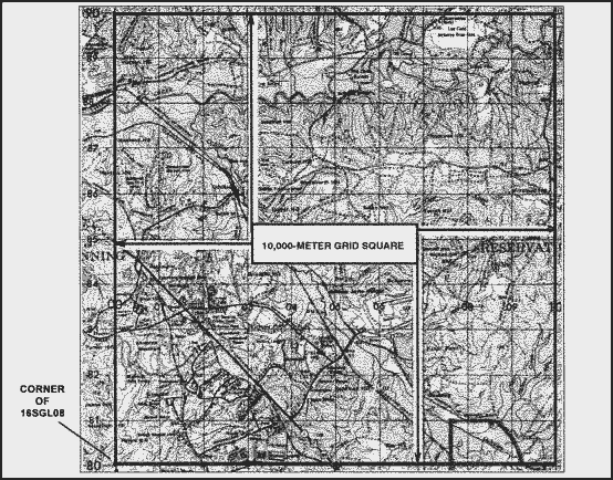
Figure 4-20. The 10,000-meter grid square.
e. 1,000-Meter Square. To obtain 1,000-meter squares, each side of the 10,000-meter square is divided into 10 equal parts. This division appears on large-scale maps as the actual grid lines; they are 1,000 meters apart. On the Columbus map, using coordinates 16SGL0182, the easting 01 and the northing 82 gives the location of the southwest corner of grid square 0182 or to the nearest 1,000 meters of a point on the map (Figure 4-21).
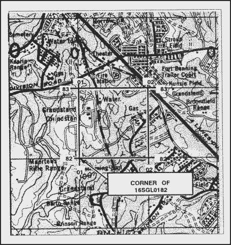
Figure 4-21. The 1,000-meter grid square.
f. 100-Meter Identification. To locate to the nearest 100 meters, the grid coordinate scale can be used to divide the 1,000-meter grid squares into 10 equal parts (Figure 4-22).
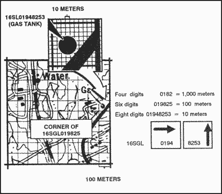
Figure 4-22. The 100-meter and 10-meter grid squares.
g. 10-Meter Identification. The grid coordinate scale has divisions every 50 meters on the 1:50,000 scale and every 20 meters on the 1:25,000 scale. These can be used to estimate to the nearest 10 meters and give the location of one point on the earth’s surface to the nearest 10 meters.
EXAMPLE: 16SGL01948253 (gas tank) (Figure 4-22).
h. Precision. The precision of a point’s location is shown by the number of digits in the coordinates; the more digits, the more precise the location.