Providing a FREE U.S. Army Board Study Guide and resources for Army Soldier and NCO Boards and SGT / SSG Promotion Boards since 1999
  Prep for Basic
Online Since 1999  
Please recommend our FREE Army Study Guide to another Soldier.
 
Browse More In:
 
 Navigation
 
 Sub Navigation
 
Civilian Job Center
Ready to transition? Find a post-military career today [Go]
 
FREE Audio Version
of our Study Guide. Choose the sections you want to study [Go]

Download & print
the most recent full version of the FREE ArmyStudyGuide.com Study Guide [Go]
 
Enter your email address to receive the Military Network newsletter.

Thank you!

You are now subscribed to the ArmyStudyGuide Newsletter. Expect your first issue shortly!

 
You are here: home > prep for basic > land navigation > cut and a fill (supplementary terrain features)

Cut and a Fill (Supplementary Terrain Features)
 

Posted Saturday, October 8, 2005

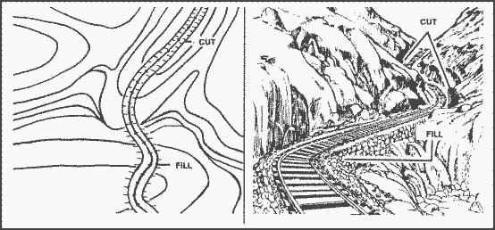
Cut. A cut is a man-made feature resulting from cutting through raised ground, usually to form a level bed for a road or railroad track. Cuts are shown on a map when they are at least 10 feet high, and they are drawn with a contour line along the cut line. This contour line extends the length of the cut and has tick marks that extend from the cut line to the roadbed, if the map scale permits this level of detail

Fill. A fill is a man-made feature resulting from filling a low area, usually to form a level bed for a road or railroad track. Fills are shown on a map when they are at least 10 feet high, and they are drawn with a contour line along the fill line. This contour line extends the length of the filled area and has tick marks that point toward lower ground. If the map scale permits, the length of the fill tick marks are drawn to scale and extend from the base line of the fill symbol

e-mail E-mail this page
print Printer-friendly page


Recently Added
Latest articles in Land Navigation

» Measure Distance on a Military Map

» Valley (Major Terrain Feature)

» Saddle (Major Terrain Feature)

» Spur (Minor Terrain Feature)

» Ridge (Major Terrain Feature)

» Hill (Major Terrain Feature)

» Handling A Compass


Misc. Information
       Recommended Reading:
       Cool Stuff We Found:
  • Heat Seeker The HeatSeeker comes with two built-in lasers that help pinpoint the heat source with incredible accuracy up to 300 yards.


e-mail E-mail this page
print Printer-friendly page
 
 
Civilian Job Translator
Match your military MOS with civilian jobs and training.
Salary & Degree Finder
Find salary and degree info for civilian careers.
 

Version 5.0 of the PDF version of our Study Guide was released on 25 June. [Go to Download Page]


Take surveys & get paid!
 
 
Search This Site:
 

| Privacy Policy | DISCLAIMER | Contact Us | Volunteer to Contribute Content | Take our quick Survey ׀
| MilitaryBaby.com | CountdownHomepage.com  |  NCOcorps.net  |  USMRC.org  | NCObusiness.com  |

This IS NOT an official or unofficial government site and is not in any way endorsed by the U.S. Government or the U.S. Military
BY USING THIS SITE YOU ARE AGREEING THAT YOU HAVE READ, UNDERSTAND AND AGREE WITH THE SITE DISCLAIMER!
Google Sitemaps Generator Tool
Copyright 1999 - 2008, ArmyStudyGuide.com. All rights reserved.
powered by Big Mediumi