|
Conditions:
Given an unknown location, a standard
1:50,000-scale military map of the area, a
compass, a straightedge, a coordinate scale,
a protractor (GTA 05-02-012), a pencil, and
two terrain features visible from your
location and identifiable on the map.
Standards:
Determined the 100,000 meter square
identification letters and six-digit
coordinates of your location to within 100
meters of the actual grid coordinates.
|
Performance Steps
|
|
1.
Use the map and compass method
(figure C-37).
|
|
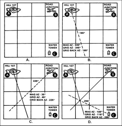
Figure C-37.
Using the map and compass
|
|
Note. The example map is not to scale-an easterly G-M angle
of 10 degrees is used in the examples.
|
a.
Determine the G-M angle of the
map you are using.
|
b.
Locate two known positions on
the ground and mark them on your map
(A, figure C-37).
|
c.
Using your compass, measure the
magnetic azimuth to one of the known
locations; change it to a grid azimuth
(B, figure C-37.)
|
(1)
If it is a westerly G-M angle,
subtract the number of degrees in the
G-M angle from your magnetic azimuth.
|
(2)
If it is an easterly G-M angle,
add the number of degrees in the G-M
angle to your magnetic azimuth.
|
d.
Change this grid azimuth to a
back azimuth.
|
e.
Place the protractor on the
map, ensuring that the zero degree
indicator on the protractor is
pointing to the top of the map
(north), and the index point is placed
center mass on this location. Place a
tick mark at the number of degrees you
want to plot. Remove the protractor
from the map and draw a line on the
map from this position on the grid
back azimuth you found, in the
direction of your unknown position.
|
f.
Repeat steps 1c through 1e for
a second (C, figure C-37), and third
(D, figure C-37) known position.
|
g.
Where these lines cross is your
location.
|
|
2.
Perform resection without a
compass (figure C-38).
|
|
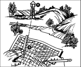
Figure C-38.
Resection without a compass
|
a.
Orient your map as closely as
you can using one of the ways you’ve
learned about finding direction:
compass, sun, watch, or stars. Then
look for some feature, such a water
tower (figure C-38, point A), that you
can also find on the map. Put a ruler
or straightedge on the map, and place
its edge next to the water tower
symbol (figure C-38, point B) on the
map. Then align the straightedge so
that it points directly at the real
water tower. Draw a line along the
straightedge or ruler (the line will
cross the symbol for the water tower
on your map).
|
|
Note. Do not move your map once it is properly oriented.
|
b.
Find another feature, such a
road junction (figure C-39, point C),
and do the same things. Lay the
straightedge on your map and point it
at the real road junction, ensuring at
the same time that its edge crosses
over the road junction (figure C-39,
point D) on the map. Draw another line
along the ruler until it crosses
(intersects) the first line. The point
where the lines cross is your
location. (figure C-39, point X) if
you do this step with a third line, it
may help location your position more
accurately.
|
|
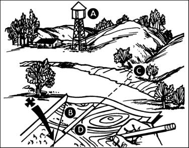
Figure C-39.
Resection without a compass continued
|
|
3.
To perform modified resection
you must be located on a linear
feature such as a road, stream bank,
railroad or ridge. First orient your
map, then find some feature that you
can also find on the map, such as the
water tower in the previous example.
Just as before, put a straightedge
through the water tower on the map and
align the straightedge so that it
points directly at the real water
tower. Draw a line along the ruler or
straightedge. The point where the line
crosses the linear feature is your
location.
|
|
Note. Always orient your map as closely as you can. The
compass is the best way to do so. If
you don’t have a ruler, use your rifle
cleaning rod or a section of radio
antenna as a straightedge.
|
Evaluation
Preparation:
Setup:
Give the soldier a standard 1:50,000-scale
military map of the local area, a compass, a
coordinate scale, a protractor (GTA
05-02-012), a pencil, a straightedge, and
the location of two known points.
Brief
Soldier: Tell the soldier to determine
the six-digit coordinates for his location.
|
Performance Measures
|
GO
|
NO
GO
|
|
1.
Determined the six-digit grid
coordinate and the 100,000 meter
square identifier of the soldier’s
position (unknown point) within 100
meters.
|
—
|
—
|
Evaluation
Guidance:
Score the soldier GO if the
performance measure is passed. Score the
soldier NO GO if the performance measure is
failed. If the soldier scores NO GO, show
what was done wrong and how to do it
correctly.
|
References
|
|
|
Required
|
Related
|
|
|
FM
3-25.26
|
|
|