|
Performance
Steps
|
|
1. Determine the effects of terrain on the vehicle
when navigating mounted.
|
a.
Vehicle speed and
mobility.
|
(1)
Great distances may be
covered quickly. Develop the
ability to estimate the distance
traveled. Meanwhile, use the
odometer, which shows the distance
traveled. Remember that .1 mile is
roughly 160 meters, and 1 mile is
about 1,600 meters or 1.6
kilometers.
|
(2)
Mobility is an
advantage while navigating. When
disoriented, mobility makes it
easier to move and reorient.
|
b.
Vehicle capabilities.
|
(1) Most military
vehicles can knock down a tree.
Larger vehicles can clear more
trees but cannot knock down
several trees at once. Find paths
between trees that are wide enough
for the vehicle (figure 071-329-1030-1).
|
|
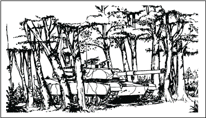
Figure 071-329-1030-1.
Vehicle capabilities
|
|
CAUTION:
During training, follow installation
SOP or local guidelines concerning
cross-country vehicle travel
|
(2) Military vehicles
are designed to climb 60-percent
(30-degree) slopes if the surface
is dry and firm. If gravel,
vegetation, or mud is on the
slope, the practical
slope-climbing capability is about
40 percent (20 degrees) (figure 071-329-1030-2).
|
|
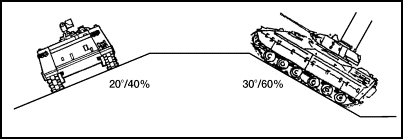
Figure 071-329-1030-2.
Climbing slope and side slope
capabilities
|
(a)
Determine the
approximate slope by looking at
the route selected on a map. One
contour line in any 100 meters
of map distance on that route
indicates a 10-percent slope.
Two contour lines indicate a
20-percent slope, and so forth.
If there are four contour lines
in 100 meters, look for another
route.
|
|
Note. The above figures are true for a 10-meter or 20-foot
contour interval. If the map has a
different contour interval, adjust the
arithmetic. For instance, if there is
one contour line in 100 meters, a
10-meter interval would give a
10-percent slope.
|
(b)
The side slope is
more important than the climbing
slope. A 40-percent side slope
is the maximum in good weather
(figure 071-329-1030-2).
Traverse a side slope slowly and
without turning. Rocks, stumps,
or sharp turns can cause a
downhill track to be thrown
under the vehicle, which is a
major recovery task.
|
(3)
For tactical reasons,
movement is often in draws or
valleys due to the cover they
provide. Side slopes make slow
movement necessary.
|
|
2. Know the effects of weather on vehicle movement.
|
a.
Weather can halt mounted
movement. Snow and ice are
dangerous. Rain and snow affect soil
load-bearing ability. Heavy rain may
restrict cross-country vehicles to
road movement.
|
b.
Adjust the route to avoid
flooded or muddy areas. A stuck
vehicle hinders combat capability.
|
|
3. Know both methods of navigation.
|
a.
Terrain association. This
is the most used method of
navigation. The navigator plans the
route for movement from one terrain
feature to another. An automobile
driver uses the same technique while
driving along the streets in a city.
He guides himself using
intersections or other landmarks.
Like a driver, the navigator selects
routes, or "streets,"
between key points, or
"intersections." These
routes must sustain vehicle travel,
and should be as direct and easy to
follow as possible. In a typical
move, the navigator determines his
location and the location of his
objective. He notes the position of
each on his map and selects a route
between the two.
|
(1)
Determine the start
point and destination.
|
(2)
Draw or visualize a
straight line between the two
points on the map.
|
(3)
Inspect the terrain
along that line for ease of
movement, for features
recognizable under predicted
weather conditions, and for
tactical considerations.
|
(4)
After analyzing the
terrain, adjust the route by doing
the following:
|
(a)
Consider tactical
aspects. Avoid skylining, select
key terrain for overwatch
positions, and select concealed
routes.
|
(b)
Consider ease of
movement. Use the easiest
possible route. Bypass difficult
terrain. A difficult route is
hard to follow, noisier, causes
more wear to the vehicle (and
possibly recovery problems), and
takes more time. Tactical
surprise is achieved by doing
the unexpected. Try to select an
axis or corridor and not a
specific route. Allow room for
vehicles to maneuver.
|
(c)
Use terrain features
as checkpoints. Checkpoints must
be easily recognizable, from a
moving vehicle, under the
current light and weather
conditions. The best checkpoints
are linear features that cross
the route. Use perennial
streams, rivers, hardtop roads,
ridges, valleys, and railroads.
The next best are elevation
changes; hills, depressions,
spurs, and draws. Look for two
contour lines of change. Less
than two lines of change cannot
be spotted while mounted.
|
(d)
Follow terrain
features. Movement and
navigation along a valley floor
or near or on the crest of a
ridgeline are easiest.
|
(e)
Determine directions.
Break the route into smaller
segments and determine the rough
direction that will be followed.
The compass is not needed; use
the main points of direction
(north, northeast, east, for
example). Before moving, note
the location of the sun and the
direction of north. Locate
changes of direction, if any, at
the checkpoints chosen.
|
(f)
Determine distance.
Obtain the total distance to be
traveled and the approximate
distance between checkpoints.
Plan to use the vehicle odometer
to keep track of distance
traveled.
|
|
Note. Convert map distance to ground distance by adding 20
percent for cross-country movement.
|
(g)
Make notes. Usually,
mental notes are adequate.
Imagine what the route will be
like and remember it.
|
(h)
Plan. Restudy the
route selected. Determine where
problems may occur and how they
may be avoided.
|
b.
Dead reckoning. Dead
reckoning means moving a set
distance along a set line. It
involves moving so many meters along
a set line, usually an azimuth in
degrees.
|
|
Note. There is no accurate method of determining direction in
vehicles.
|
(1)
Dead reckoning with
steering marks. This procedure is
the same as it is for on foot
travel.
|
(a)
Dismount from the
vehicle.
|
(b)
Move away from the
vehicle (about 50 meters).
|
(c)
Set the azimuth on
the compass and choose a
steering mark (rock, tree,
hilltop) in the distance on that
azimuth.
|
(d)
Remount and have the
driver identify the steering
mark. Proceed to it in as
straight a line as possible.
|
(e)
On arrival at the
steering mark or when direction
is changed, repeat paragraphs
(a) through (c) for the next leg
of travel.
|
(2)
Dead reckoning without
steering marks. Use this only in
flat, featureless terrain.
|
(a)
Dismount from the
vehicle, which has been
positioned in the direction of
travel. Move about 50 meters to
the front of the vehicle.
|
(b)
Face the vehicle and
read the azimuth to the vehicle.
|
(c)
By adding or
subtracting 180 degrees,
determine the forward azimuth
(direction of travel).
|
(d)
Have the driver drive
on a straight line toward you.
|
(e)
Remount the vehicle,
hold the compass as it will be
held while the vehicle is
moving, and read the azimuth to
the front.
|
(f)
The compass swings
off the azimuth determined, but
it should pick up a constant
deviation. For instance, the
azimuth to the steering mark was
75 degrees while you were away
from the vehicle. When you
remounted, and the driver drove
straight forward, the compass
showed 67 degrees. There is a
deviation of minus 8 degrees.
All that is needed is to hold
the 67-degree heading.
|
(g)
At night, do the same
thing without a steering mark.
From the map, determine the
azimuth of travel. Line the
vehicle up on that azimuth, then
move well in front of the
vehicle. Be sure it is aligned
correctly. Mount, have the
driver move slowly forward, and
note the deviation.
|
|
Note. If the vehicle has a turret, traversing the turret
changes the deviation.
|
(3)
Turret alignment. If
the vehicle has a stabilized
turret, another method is
alignment of the turret on the
azimuth to be traveled. Switch the
turret stabilization system ON.
The gun tube remains pointed at
the destination no matter which
way the vehicle is turned.
|
|
CAUTION:
If you have to take the turret
off-line to engage a target, repeat
the entire process
|
|
Note.
This technique works, and it is not
harmful to the stabilization system.
However, the vehicle is subject to
stabilization drift; therefore, use
this technique for no more than 5,000
meters before resetting.
|
(4)
Distance factor.
Computing the distance factor in
dead reckoning is usually a simple
process. Determine the map
distance to travel and add 20
percent to convert to ground
distance. Use the vehicle odometer
to control the distance of travel.
|
|
4. Learn to combine and use both methods.
|
a.
Terrain association is
fast and error-tolerant. It is the
best method under most
circumstances, and it can be used
day or night.
|
b.
Dead reckoning is
accurate if done
correctly-precision is a
requirement. Dead reckoning is slow,
but works in flat terrain.
|
c.
Often, dead reckoning and
terrain association are combined.
Use dead reckoning to travel across
a large, flat area to a ridge. Use
terrain association for the rest of
the move.
|
d.
The ability to use both
methods is required. Probable
errors, in order of frequency, are
as follows:
|
(1)
Failure to determine
distance(s) to be traveled.
|
(2)
Failure to travel the
proper distance.
|
(3)
Failure to properly
plot or locate the objective.
|
(4)
Failure to select
easily recognizable checkpoints or
landmarks.
|
(5)
Failure to consider the
ease of movement factor.
|