|
Conditions:
Given a standard 1:50,000-scale military
map, a strip of paper with a straight edge,
and a pencil.
Standards:
1. Determined the straight-line distance, in
meters, between two points, with no more
than five percent error.
2. Determined the road (curved line)
distance, in meters, between two points,
with no more than ten percent error.
|
Performance Steps
|
|
1.
Identify the scale of the map.
The map scale is the ratio (1:50,000)
of the distance on the map (1 inch)
compared to the distance on the ground
(usually 50,000 inches).
|
|
2.
Convert a straight-line map
distance to miles, meters, or yards
using the map’s bar scale (figure
C-27).
|
|

Figure C-27.
Bar scales
|
a.
For map distances equal to or
less than one inch:
|
(1)
Line up the straight edge of a
strip of paper with the beginning and
ending points on the map.
|
(2)
Mark on the straight edge of
the paper the beginning and ending
points (figure C-28).
|
|
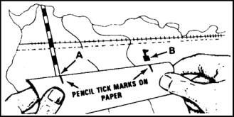
Figure C-28.
Measuring distance
|
|
(3)
Match the marks on the paper
with the appropriate bar scale (figure
C-29).
|
|
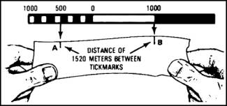
Figure C-29.
Determining distance
|
(4)
Determine the distance on the
scale that compares to the distance on
the paper.
|
b.
For map distances greater than
one inch:
|
(1)
Line up the straight edge of a
strip of paper with the beginning and
ending points on the map.
|
(2)
Mark the beginning and ending
points on the straight edge of the
paper (figure C-28).
|
(3)
Place the starting point on the
paper under the zero on the bar scale.
|
(4)
Measure off 4,000 meters and
place a new tick mark on the paper.
|
(5)
Place the new tick mark under
the zero on the bar scale.
|
(6)
Determine if the end point
falls within the bar scale.
|
(a)
Record the value on the scale
of the end point if the end point fits
on the scale.
|
(b)
Add 4,000 meters to the value
you derived in step 2b(6)(a). This is
the total difference.
|
(7)
Determine if the end point does
not fall within the bar.
|
(a)
Repeat steps 2b(4) and (5)
until the end point falls within the
bar.
|
(b)
Add 4,000 meters to the value
you derived in step 2b(6)(a) for each
time you performed step 2b(4). This is
the total difference.
|
|
3.
Convert a road map distance to
miles, meters, or yards using the
map’s bar scale (figure C-28). This is
the actual distance you have to travel
to reach the point whose straight line
distance you identified in step 2.
|
a.
Line up the straight edge of a
strip of paper with the beginning
point and the point at which the road
makes the first curve on the map.
|
b.
Mark on the straight edge of
the paper the beginning and curve
points (figure 27).
|
c.
Repeat steps 3a and b (each
time using the point of the curve as
the next beginning point) until you
reach the end point.
|
d.
Use step 3 to determine the
road distance in miles, meters, or
yards as appropriate.
|
(1)
If the total distance measured
on the paper is equal to or less than
1 inch, use steps 2a(3) and (4).
|
(2)
If the total distance measured
on the paper is more than 1 inch, use
steps 2b(3) through (7).
|
Evaluation
Preparation:
Setup:
In the field or classroom, give the soldier
a 1:50,000-scale military map, a strip of
paper with a straight edge, and a pencil. On
the map, plot a straight-line distance of
3,000 to 4,000 meters. Mark this distance
points A and B. On a road or trail, plot a
curved-line distance of 3,000 to 4,000
meters with at least two changes of
direction. Mark this distance points C and
D.
Brief
Soldier: Tell the soldier that he or she
must determine the straight-line distance
between points A and B with no more than 5
percent error, and the curved-line distance
between points C and D with no more than 10
percent error. He or she must either write
down the correct answers or state the
answers when asked by the scorer.
|
Performance
Measures
|
GO
|
NO
GO
|
|
1.
Identified the scale of the
map.
|
—
|
—
|
|
2.
Converted the straight-line map
distance to miles, meters or yards
using the map’s bar scale with no more
than 5 percent error.
|
—
|
—
|
|
3.
Converted the road map distance
to miles, meters, or yards using the
map’s bar scale with no more than 10
percent error.
|
—
|
—
|
Evaluation
Guidance:
Score the soldier GO if all
performance measures are passed. Score the
soldier NO GO if any performance measure is
failed. If the soldier scores NO GO, show
the soldier what was done wrong and how to
do it correctly.
|
References
|
|
|
Required
|
Related
|
|
|
FM
3-25.26
|
|
|