Land Nav Task 11 – Orient a Map to the Ground by Map-Terrain Association
Land Nav Task 11 - Orient a Map to the Ground by Map-Terrain Association
Standards: Oriented the map to within 30 degrees of north.
Conditions:
Given a standard 1:50,000-scale military map
in the field in daylight.
Standards:
Oriented the map to within 30 degrees of
north.
Performance Steps
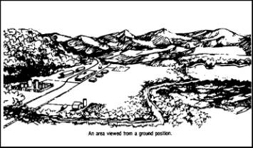
1. Match terrain features
appearing on the map with physical
features on the ground (figure C-34).
Figure C-34. Features used to orient
map
a. Hold the map in a horizontal
position.
b. Line up features on the ground
with those on the map.
2. Check orientations obtained by
this method by placing a compass along
one of the north-south grid lines to
keep from orienting the map in the
wrong direction (that is, 180 degrees
out) or by aligning two or more
features. Incorporate the declination
constant in determining the 30
degrees.
Evaluation
Preparation:
Setup:
Use an area of terrain with identifiable
terrain features, natural and/or man-made.
Provide a field table and a 1:50,000-scale
map of the area.
Brief
Soldier: Tell the soldier to use the
terrain features around him or her, the
soldier must orient the map to within 30
degrees of north.
Performance Measures
GO
NO
GO
1. Matched terrain features by
holding map in horizontal position and
lining up features on the ground.
—
—
2. Checked orientations.
—
—
Evaluation
Guidance: Score the soldier GO if all
performance measures are passed. Score the
soldier NO GO if any performance measure is
failed. If the soldier scores NO GO, show
the soldier what was done wrong and how to
do it correctly.
This is a private website that is not affiliated with the U.S. government, U.S. Armed Forces or Department of Veteran Affairs. U.S. government agencies have not reviewed this information. This site is not connected with any government agency. If you would like to find more information about benefits offered by the U.S. Department of Veteran Affairs, please visit the official U.S. government web site for veterans’ benefits at http://www.va.gov.
The sponsored schools featured on this site do not include all schools that accept GI Bill® funding or VA Benefits. To contact ArmyStudyGuide, email us.
Disclosure: EducationDynamics receives compensation for the featured schools on our websites (see “Sponsored Schools” or “Sponsored Listings” or “Sponsored Results”). So what does this mean for you? Compensation may impact where the Sponsored Schools appear on our websites, including whether they appear as a match through our education matching services tool, the order in which they appear in a listing, and/or their ranking. Our websites do not provide, nor are they intended to provide, a comprehensive list of all schools (a) in the United States (b) located in a specific geographic area or (c) that offer a particular program of study. By providing information or agreeing to be contacted by a Sponsored School, you are in no way obligated to apply to or enroll with the school.
This is an offer for educational opportunities that may lead to employment and not an offer for nor a guarantee of employment. Students should consult with a representative from the school they select to learn more about career opportunities in that field. Program outcomes vary according to each institution’s specific program curriculum. Financial aid may be available to those who qualify. The financial aid information on this site is for informational and research purposes only and is not an assurance of financial aid.
VFW $30,000 Scholarship!
Write an essay on the annual patriotic theme. This year’s theme is, “Why Is The Veteran Important?”